Which weather app?

franksingleton

Well-known member
Joined
27 Oct 2002
Messages
3,480
Location
UK when not sailing
weather.mailasail.com

GHA

Well-known member
Joined
26 Jun 2013
Messages
12,239
Location
Hopefully somewhere warm
Visit site
As ECMWF Effective resolution is 0.5 degrees that is difficult to explain. From La Rochelle northward or, at least north of Ile d’Yeu we often found that the GFS got the sea breeze effect well. UKV can get the Solent sea breezes but may not/
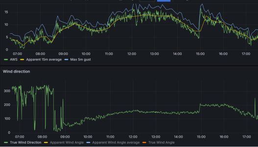
Not happening in the next few days so can't get a screen shot but somehow it manages it. And as you know onboard the trusty raspberry pi records it all, this from last week shows whatever is happening quite well building in the morning & going to the south. Then something happens at 15:00...🤔 1712226453382.png

Could stare at this stuff for hours 😎
Though not sure if it's just sea breeze, very mountainous here, some sort of vortex effect maybe?

Though these days in a new anchorage all the models are guilty of being wrong til proven otherwise 😁

Useful is maybe a better description than "right"....
 

franksingleton

Well-known member
Joined
27 Oct 2002
Messages
3,480
Location
UK when not sailing
weather.mailasail.com
When I look at Windy, Ventusky, meteoblue global displays, I always wonder what is the actual resolution being provided. They may say ECMWF 9 km, but that does not say that the display is 9km res. How much interpolation is there?
BTW, there is always some confusion when res is given in km. Models always (usually?) use grids defined in latitude/longitude. So, PredictWind has been known to say that its ECMWF data are on a 8 km grid. In fact, I believe that the ECMWF and UK both use grids equating to 0.1 degree lat/long. This is another way in which third party suppliers try to con you.
 

Laser310

Well-known member
Joined
15 Sep 2014
Messages
1,272
Visit site
As ECMWF Effective resolution is 0.5 degrees that is difficult to explain. From La Rochelle northward or, at least north of Ile d’Yeu we often found that the GFS got the sea breeze effect well. UKV can get the Solent sea breezes but may not/

UKV is a CPM (convection permitting model), and I find that those can do quite a good job with sea breezes. Global models are not, generally, convection permitting. Nevertheless, i have seen hints of sea breezes in them.

I have more experience with the US HRRR, but it often does a surprisingly good job in complex geographies; opposing sea breezes on opposing shores early in the day, which then get overridden by the advancing front of the regional sea breeze. They can also sometimes forecast evening land breezes.

In addition to UKV, Arome is another CPM covering European areas that's widely available.

Bear in mind, that forecasting sea breezes for yachtsmen is not the primary goal of CPM's. Usually. forecasting severe convective storm cells, intense rain, and flooding is what they're after.

Some of these models even do a decent job of forecasting the development of specific convective cells in the actual locations where they eventually form.

For racing, i have seen that they can be used to guess at where the wind will fill in first in the inevitable wind hole behind the cell.

The HRRR is quite amazing sometimes. Unlike most CPMs, HRRR is initialized and run every hour. There is a version with 15 minute time steps. , and a version (run 4 X a day) that goes out 48hrs. And, you can easily get the gribs.
 

franksingleton

Well-known member
Joined
27 Oct 2002
Messages
3,480
Location
UK when not sailing
weather.mailasail.com
UKV is a CPM (convection permitting model), and I find that those can do quite a good job with sea breezes. Global models are not, generally, convection permitting. Nevertheless, i have seen hints of sea breezes in them.
I have never heard the term CPM. The usual term in modelling is Non-hydrostatic for models that can calculate convective processes. Models with grids larger than 10km were usually hydrostatic. However, in recent years ECMWF and UK UM (both 10km)have been run as non-hydrostatic as have ICON, GFS etc even though these have grids of 0.125 degrees, UKV, HRRR, AROME, ICON-DE etc are all NMM - Non-hydrostatic meso-scale models.
I have more experience with the US HRRR, but it often does a surprisingly good job in complex geographies; opposing sea breezes on opposing shores early in the day, which then get overridden by the advancing front of the regional sea breeze. They can also sometimes forecast evening land breezes.
It was some 10 years ago that a former colleague told me that the UKV could predict the Solent sea breeze but could not be guaranteed to do so. It really is a matter of having a grid that can define sufficiently accuracy the topography.
In addition to UKV, Arome is another CPM covering European areas that's widely available.
ICON-DE and HARMONIE are two more European NMM models.
Bear in mind, that forecasting sea breezes for yachtsmen is not the primary goal of CPM's. Usually. forecasting severe convective storm cells, intense rain, and flooding is what they're after.
Quite correct.
Some of these models even do a decent job of forecasting the development of specific convective cells in the actual locations where they eventually form.
In fact, they will rarely model single cells but might model small intense storms. More likely, they will run LAM ensembles.
For racing, i have seen that they can be used to guess at where the wind will fill in first in the inevitable wind hole behind the cell.

The HRRR is quite amazing sometimes. Unlike most CPMs, HRRR is initialized and run every hour. There is a version with 15 minute time steps. , and a version (run 4 X a day) that goes out 48hrs. And, you can easily get the gribs.
UKV runs hourly. The app is updated hourly. I would expect AROME/ICON-DE also to be run hourly.
 

Laser310

Well-known member
Joined
15 Sep 2014
Messages
1,272
Visit site
I have never heard the term CPM. The usual term in modelling is Non-hydrostatic

I'm not sure they are the same. I read in a paper somewhere someone saying that it is a misconception that hydrostatic models do not allow convection. I agree that it makes more intuitive sense that a convective model would have to be non hydrostatic.


royal met soc has used the term "convection permitting" for some time, e.g.;

https://www.researchgate.net/profil...ment_milestone&origin=journalDetail&_rtd=e30=

and

https://rmets.onlinelibrary.wiley.com/doi/full/10.1002/qj.3921

In the US, NOAA uses the term "CAMs" for convection allowing models. CPM is the Euro term - EC uses it as well.

i read on one of the sites where i view the UKV that it runs 8 times per day - every 3hrs
 

franksingleton

Well-known member
Joined
27 Oct 2002
Messages
3,480
Location
UK when not sailing
weather.mailasail.com
I'm not sure they are the same. I read in a paper somewhere someone saying that it is a misconception that hydrostatic models do not allow convection. I agree that it makes more intuitive sense that a convective model would have to be non hydrostatic.
Global NWP models around the turn of the century used to run on grids of around 50km. That is far larger than the scale of convection. These models were hydrostatic. Convective heat processes could not be calculated and convective heat transfer was estimated by a process known as parameterization, a long word meaning intelligent guess. When model grids decreased to around 10-12km, convective processes could be included explicitly. Most global models are now non-hydrostatic. Fairly obviously, the finer the grid the better convection can be modelled. It is still a bit hit and mis because of the problems of predicting accurate cloud cover.
The only exception that I know is the PredictWind “proprietary” model which still, I believe, uses a 50km grid.
The term Convection Permitting seems to be used for climate models. I have not delved into climate modelling recently so had not seen the term.
royal met soc has used the term "convection permitting" for some time, e.g.;

https://www.researchgate.net/profile/Cristina-Charlton-perez/publication/299544256_Convection-permitting_models_A_step-change_in_rainfall_forecasting/links/5fb7aa5692851c933f431b73/Convection-permitting-models-A-step-change-in-rainfall-forecasting.pdf?_sg[0]=started_experiment_milestone&origin=journalDetail&_rtd=e30=

and

https://rmets.onlinelibrary.wiley.com/doi/full/10.1002/qj.3921

In the US, NOAA uses the term "CAMs" for convection allowing models. CPM is the Euro term - EC uses it as well.

i read on one of the sites where i view the UKV that it runs 8 times per day - every 3hrs
See Numerical weather prediction models where it says that UKV runs to 54 hours at 00, 06,09, 12, 18, 21 hour and to 12 hours at all other hours.
 
Last edited:

GHA

Well-known member
Joined
26 Jun 2013
Messages
12,239
Location
Hopefully somewhere warm
Visit site
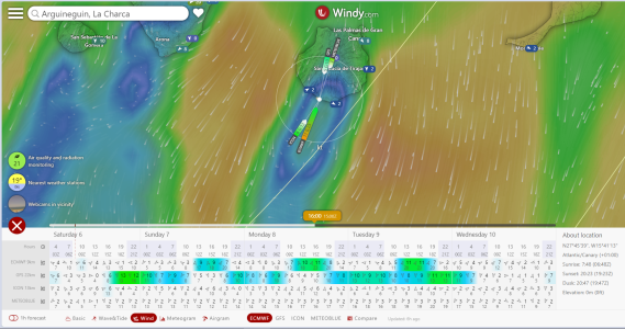
The windy 9Km ecmwf does seem to usually be very good at picking up the afternoon onshore winds which pick up over about a 15Nm southern coast here in Gran Canaria which presumably would be missing from the 0.4Deg model.
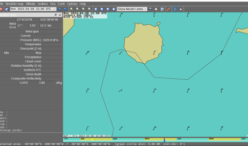
Going back to this one, the opencpn downloaded 0.4deg for monday afternoon show no onshore wind, curser isn't shown on the screengrab but is around the centre of the south of the island >
1712390829231.png

Northerly 10Kts.

And windy ecmwf shows gusting 23Kts from the south.
1712390923145.png

We`ll see over the next few days but run shore to the supermarket will be planned for the mornings next week, it's usually right 🙂

Just sharing what happens, next anchorage it might not be useful.
 

AntarcticPilot

Well-known member
Joined
4 May 2007
Messages
10,095
Location
Cambridge, UK
www.cooperandyau.co.uk
When I look at Windy, Ventusky, meteoblue global displays, I always wonder what is the actual resolution being provided. They may say ECMWF 9 km, but that does not say that the display is 9km res. How much interpolation is there?
BTW, there is always some confusion when res is given in km. Models always (usually?) use grids defined in latitude/longitude. So, PredictWind has been known to say that its ECMWF data are on a 8 km grid. In fact, I believe that the ECMWF and UK both use grids equating to 0.1 degree lat/long. This is another way in which third party suppliers try to con you.
I have discussed the use of grids defined on Plat Carree projections (i.e. x =longitude, y=latitude) with modellers several times, raising the issues that:
  1. Grid cells are not rectangular, but approximately trapezia (they are on the surface of a sphere, so they aren't trapezia, but that's a really pedantic point!)
  2. Grid cells are not of uniform size; they decrease in area towards the poles.
  3. Grid cells are not of uniform shape; they become narrower with respect to their latitudinal extent as they approach the poles.
The answers I've had back is that the models incorporate fudge factors to account for the non-uniformities of the grid. But why don't the models use a projection that allows true equal area grid cells? There are many possibilities, mostly mathematically trivial to implement. I can see that in the early days of modelling, using lat/long based grids would save precious computing resources, but these days the extra processing would be insignificant and potentially offset by the reduction in complexity of the actual modelling.
 

GHA

Well-known member
Joined
26 Jun 2013
Messages
12,239
Location
Hopefully somewhere warm
Visit site
I do not know how they generate those winds. Looking at the HARMONIE modrl, they do not show..
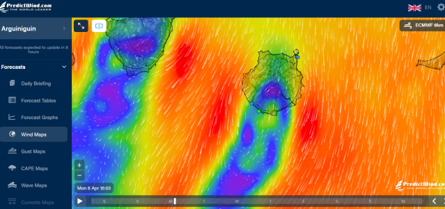
Dunno either, not sure there's a source of 0.1deg ecmwf gribs to see what the data is actually like, Same in predict wind, they call it 8Km & do even more pretty colouring in to make us think it's the best one! 🤔
But it seems repeatable enough to be useful in this particular place. 😎
Pity you can't pay extra & control the swell direction in the anchorage... 😁

1712400399514.png
 

franksingleton

Well-known member
Joined
27 Oct 2002
Messages
3,480
Location
UK when not sailing
weather.mailasail.com
I have discussed the use of grids defined on Plat Carree projections (i.e. x =longitude, y=latitude) with modellers several times, raising the issues that:
  1. Grid cells are not rectangular, but approximately trapezia (they are on the surface of a sphere, so they aren't trapezia, but that's a really pedantic point!)
  2. Grid cells are not of uniform size; they decrease in area towards the poles.
  3. Grid cells are not of uniform shape; they become narrower with respect to their latitudinal extent as they approach the poles.
The answers I've had back is that the models incorporate fudge factors to account for the non-uniformities of the grid. But why don't the models use a projection that allows true equal area grid cells? There are many possibilities, mostly mathematically trivial to implement. I can see that in the early days of modelling, using lat/long based grids would save precious computing resources, but these days the extra processing would be insignificant and potentially offset by the reduction in complexity of the actual modelling.
To be able to predict weather somewhere, you have to be able to predict everywhere. You cannot have a rectangular grid to cover the spherical earth. I suppose that you might have specific small domains for models covering small areas but you would still have to feed in boundary conditions. With spherical co-ordinates, you can select any area, anywhere and the models will work with whatever grid spacing you wish.
You do not have to compute on a rectangular grid, x/y or lat/lon. DWD uses a icosahedral grid, Wetter und Klima - Deutscher Wetterdienst - Numerical weather prediction models - ICON (Icosahedral Nonhydrostatic) Model.
There is a paper Grids in Numerical Weather and Climate Models a it different grids. I do not know why the Met O, ECMWF/GFS all use some form of rectangular grid. Probably the mathematics is easier and, given the fairly smal global grids, it makes little difference to the outcome.
 

AntarcticPilot

Well-known member
Joined
4 May 2007
Messages
10,095
Location
Cambridge, UK
www.cooperandyau.co.uk
To be able to predict weather somewhere, you have to be able to predict everywhere. You cannot have a rectangular grid to cover the spherical earth. I suppose that you might have specific small domains for models covering small areas but you would still have to feed in boundary conditions. With spherical co-ordinates, you can select any area, anywhere and the models will work with whatever grid spacing you wish.
You do not have to compute on a rectangular grid, x/y or lat/lon. DWD uses a icosahedral grid, Wetter und Klima - Deutscher Wetterdienst - Numerical weather prediction models - ICON (Icosahedral Nonhydrostatic) Model.
There is a paper Grids in Numerical Weather and Climate Models a it different grids. I do not know why the Met O, ECMWF/GFS all use some form of rectangular grid. Probably the mathematics is easier and, given the fairly smal global grids, it makes little difference to the outcome.
Using an equal area grid would not confined you to a limited area; there are plenty of whole earth equal area projections, and cylindrical equal area projections would provide cell boundaries aligned with geographic coordinates. To me it's just such an obvious approach - indeed, I've advised many of my former colleagues along those lines! Of course, lat/long cells fail badly in the polar regions.
 

franksingleton

Well-known member
Joined
27 Oct 2002
Messages
3,480
Location
UK when not sailing
weather.mailasail.com
Using an equal area grid would not confined you to a limited area; there are plenty of whole earth equal area projections, and cylindrical equal area projections would provide cell boundaries aligned with geographic coordinates. To me it's just such an obvious approach - indeed, I've advised many of my former colleagues along those lines! Of course, lat/long cells fail badly in the polar regions.
I really do not know the answer. DWD uses its icosahedral grid but, to the best of my knowledge ECMWF, UK, GFS all use lat/lon grids. ECMWF/UK have some excellent mathematicians. There can be no reason why they should not follow DWD. I can only assume that it must be be for some cost/benefit reason. Triangular/hex and other grids have been around for a long time now.
 

franksingleton

Well-known member
Joined
27 Oct 2002
Messages
3,480
Location
UK when not sailing
weather.mailasail.com
Re #28/29 I am still confused about CAM/CPMs cf non-hydrostatic. The latter term means that they solve the equations of motion in the vertical on the scale of convection. The Met Office does not seem to use the term CPM except for climate modelling. I suspect that NOAA uses the term CAM as being a clearer description of what the model does. I am pretty sure that the terms are synonymous.
 

AntarcticPilot

Well-known member
Joined
4 May 2007
Messages
10,095
Location
Cambridge, UK
www.cooperandyau.co.uk
I really do not know the answer. DWD uses its icosahedral grid but, to the best of my knowledge ECMWF, UK, GFS all use lat/lon grids. ECMWF/UK have some excellent mathematicians. There can be no reason why they should not follow DWD. I can only assume that it must be be for some cost/benefit reason. Triangular/hex and other grids have been around for a long time now.
But do they have excellent geodesists? The mathematics is not difficult - I couldn't do it if it was ☺️
 

GHA

Well-known member
Joined
26 Jun 2013
Messages
12,239
Location
Hopefully somewhere warm
Visit site
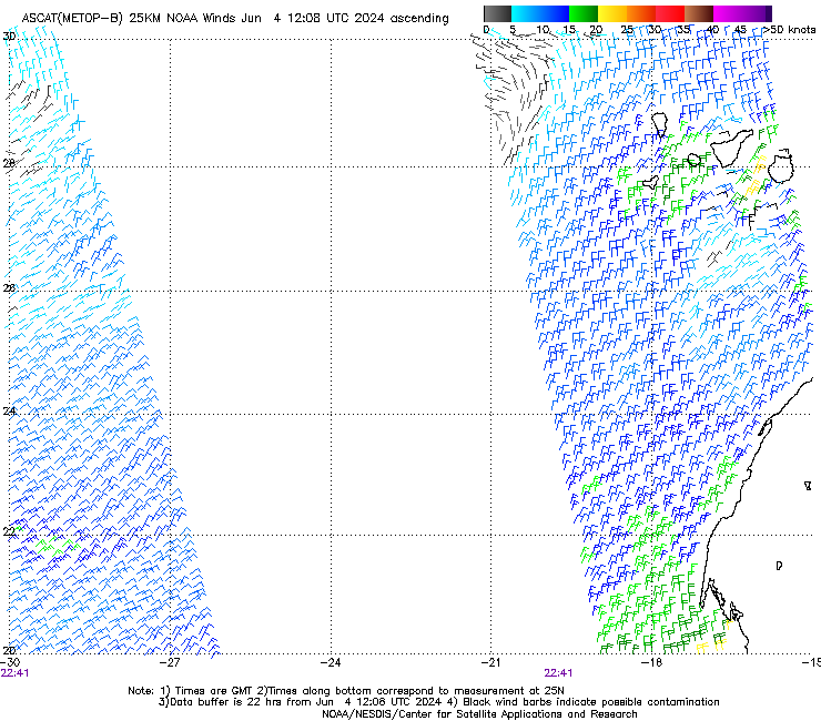
Back to the original question, but not so relevant to the UK, I use ascat sometimes to see what really happened compared to the models..
https://manati.star.nesdis.noaa.gov/datasets/ASCATBData.php
WMBas123.png


& DeepZoom Trip to get an idea of what wind might be expected for longer passages. Cool site but takes a moment to get the hang of.
 
Top